
Headtorch in the daytime? Must be the BGR.
I have greatly enjoyed a spot of fell-running on holidays to Keswick and was inspired by the obligatory copy of Feet in the Clouds I picked up from George Fisher. But attempting the Bob Graham Round (BGR) -- an epic ultramarathon mountain challenge of about 65 miles, 42 named peaks and 25000 feet of climbing, to be completed in 24 hours -- is difficult on several counts if, as I do, you live somewhere flat and distant from the lakes.
But it can be done, and this is how it worked out successfully for me, despite living in Cambridge.
Watch the YouTube video to see how it all went:
Click here to open video at http://youtu.be/AEbuWZN8oxE
As an appendix in that, I show all of the kit I had, and what food and drink I got through, which should be useful to anyone doing a similar unsupported round.
In brief though:
I initially planned my 2010 practice trips using this mtbguru file as a starting-point, as it looked like a mostly genuine track from someone who had actually done it. I split that up into manageable chunks and made some tweaks where I felt the route could be improved using the 'drag edit' mode on www.bikehike.co.uk, though I sometimes fell into the trap of moving the route onto what looked like a path in the aerial photos, only to discover on the ground that it was a rocky stream-bed! I also made use of the very helpful notes on Bob Wightman's site.
After running each section in practice in 2010, I made some corrections, and used the corrected tracks for my real attempt in 2013. On the day I then took a few short-cuts from the plotted route, which made it better; but also I was sometimes slow to notice I should be veering off a nice path, or initially took the wrong line heading off a summit while faffing with the camera or phone; and I even ran the wrong way on the road for a short time near the end. So while you're welcome to use this track, be warned it isn't perfect. Watch out for pointless jinks and doubling-back where I went slightly wrong on the day. It's best to visualise where the track is aiming for the next couple of hundred metres and find your own way on the ground. (I lost the path going down Sca Fell and so had to cross a barbed wire fence at the bottom, too.)
Download my full BGR GPX track here! (Right-click... Save As)
That is one big file combined from three saved sessions on the 310XT and the track log from the eTrex. You may well have to split it into smaller chunks, and maybe reduce the point density (I used Course Compactor), to use it with your device.
The Hall's Fell ridge descent from Blencathra is very slippery when wet, and took me ages in a practice run the week before as I didn't want to kill myself. In my real BGR the rock was dry (though I still slipped once and got some cuts and scrapes). Had it been wet, I would have taken this untried route from Blencathra to Threlkeld via the Doddick ridge, which I heard is much safer (and therefore quite likely quicker in the wet, though slightly further):
Untried Blencathra wet descent route via Doddick (TCX format) (Right-click... Save As)
Disclaimer: use my tracks at your own risk!
The waypoints are really important (and motivating!) for seeing when a peak is coming up and making sure you've got right up to it.
Download my BGR waypoints here! (GDB format) (Right-click... Save As)
Download my BGR waypoints here! (GPX format) (Right-click... Save As)
Disclaimer: I prepared those files so long ago that I'm no longer sure they correspond to the points I found correct in my eTrex, but they should be.
WARNING! I may have got Great Calva wrong; I was alerted much later reading someone else's blog that it's a double peak, and the 'nearer' one is slightly lower, so I didn't actually reach the correct summit. As I visited another little peak later and added some distance accidentally, I'm not too worried overall!
I am an experienced marathon runner, but when I holiday somewhere mountainous I usually fall into the trap of enthusiastically running up some modest hill on the first day, only to find I can barely walk for the next few days as a result, wasting half my holiday in fell-running terms. The main problem is that living somewhere flat, my quads are just not adapted to coping with the eccentric work of steep descents, and my calves struggle a little with the climbing too.
So before arriving in the Lakes, I did specific climb/descent training of 3 sorts over about 2 months:
All of those needed a lot of repititions as none were very high. For the BGR, the longest session I did on the stairs was just over 2 hours continual two-at-a-time up and down 73 steps [recounted this year, previously thought 63!], 100 repeats for a total of 1400m climb and descent, and in one session I did 50 repeats of Castle Hill including the mound (getting on for 20 miles just on that, as part of a longer run). Pretty mind-numbing, but then the BGR needs some determination anyway!
But even that wasn't quite enough by itself. When I completed the BGR in the second week of a fortnight's family holiday in Keswick, I made sure to do a reasonably tough convenient section (Keswick-Threlkeld and back via the railway path) the first day we arrived, to shock my legs into the 'real thing' a bit with time to recover and improve for the second week, and then tapered down with one quick run up and down Skiddaw and a couple of small sessions up and down Latrigg as my BGR attempt approached.
Part of the challenge of the BGR has traditionally been to select and successfully follow an optimal path between the peaks, partly in darkness and often in bad weather. That means many practice runs, as the best paths are not always shown on the map. (Often the public footpaths defined on the map bear no relationship to sometimes good major paths on the ground, which are usually shown too. In some places the official paths are now being "corrected" however.)
And even if you had a perfect route drawn on the map, navigating it for the first time using compass and (where necessary) counting paces would just be too slow to meet the time constraint of the BGR, so repeated practice would be required to learn the route well enough not to need much navigational effort on the day.
Living with a family in East Anglia, it is just not practical or desirable for many reasons to make weekend trips to the Lakes to recce and learn the route in the traditional manner.
Fortunately navigation is now of course a solved problem, as we have GPS. And preparing detailed GPS tracks to follow is made much more practical using the mashup at www.bikehike.co.uk which gives both the OS map view, and the aerial pictures, which often show the actual paths (where present) very nicely.
Does using GPS detract from the challenge of the BGR? Well yes, in part, but frankly it is the only way I could practically do it, as repeated practice runs aren't an option. And the formidable physical challenge remains undiminished, and was quite enough to satisfy me.
Using carefully pre-plotted GPS routes, I recce'd the whole route in stages in 2010, and did the real thing in one go in 2013 after some corrections. (See above for tracks.)
I have a Garmin eTrex Vista HCx, which can show maps (including those derived from OpenStreetMap with paths marked). The problem with it is that you need your hands free to grab rocks or claw your way up mossy slopes, and a handheld gadget would inevitably get dropped or damaged. So I didn't want to use that.
I also had my Forerunner 305 wrist-mounted GPS, intended for running. It supports a small simple map screen, on which you can follow a pre-plotted "course" (grey wiggly line) and display waypoints (e.g. the 42 peaks). This worked really well. However, the 10-hour battery life would not cover a proper BGR attempt. So for the BGR, I grafted a USB socket onto my Garmin to make external charging possible for a total battery life of about 50 hours. That worked really nicely in practice sessions.
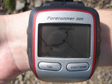
Here are some pictures of the 305 screen with my Dunmail Raise to Honister Pass course loaded and all of the Bob Graham peaks waymarked. When running I would usually have it zoomed it to show a 200' to 500' scale, with the map oriented 'track up', but these pictures show a wider view with 'north up':
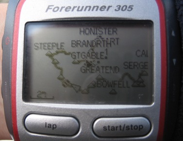
I actually prepared the waypoints on the eTrex Vista, which shows OS grid references (and had an OSM map loaded with some of them), then used the MapSource program to transfer them to the 305.
For my actual BGR attempt though, I had a bit of a nightmare. In my first practice run of the holiday, I got lashed with rain coming down Blencathra, and my modified 305 got wet inside and permanently died. My mods didn't expose the innards, but it had loudspeaker holes which did -- if only I'd covered them up! I'd run in the rain with it for about 3 years without a problem though.
So I made an emergency purchase of a Garmin 310XT while in Keswick. This similarly supports a map screen OK (all the running-specific Forerunners now don't, which is a great shame), though with some annoying long drawing delays with a large route plotted. Also it doesn't work with MapSource or BaseCamp, so I spent hours the night before the BGR manually entering waypoints for every peak (in OS grid format which it does support, which is nice). The peak waypoints were essential for knowing when I'd bagged each one, and accurately homing in on it, especially in the dark.
The 310XT spontaneously turned off after 14 hours descending Sca Fell. I turned it back on again but gave an immediate battery warning, so I saved the session and switched to the eTrex, lashed to my rucksack with string in case I dropped it. I tucked it inside my shirt when I needed both hands; a bit awkward, but it got me round. And yes I did scratch the screen quite badly too, putting it down on rocks the wrong way up while changing headtorch batteries. Afterwards when I came to recharge the 310XT, it claimed 39% battery remaining, so I don't know why it turned off by itself.
Note: the Garmin Fenix looks perfect for the BGR, with OS grid references, the map screen so you can follow a wiggly line, and a battery life of "up to 50 hours". However, I didn't go for it because a) it's eye-wateringly expensive and b) after the BGR, I wanted a watch that was good for my normal running training and racing, that could display the 4 data fields I was used to; the Fenix however has a very poor screen resolution compared to the Forerunners. So it wasn't for me.
I wanted to remember details of where I felt I had gone wrong on my 2010 practice runs, and initially depended on just remembering things. Paper and pen are no good in the wind and rain. But on my last practice, I made voice memos on my running "emergency phone", which worked really well, even though it was also in a plastic bag for safety.
My special phone is just a Nokia 5140i picked up on eBay with a prepay SIM from O2 Eire. In the UK, it is roaming, so it connects to all 4 2G networks -- which really helps in the Lakes, where coverage is so patchy. That phone model is water-resistant (not proof), shock resistant, and has a built-in electronic compass and LED torch -- all good stuff for outdoor adventures. For my real BGR, I wrapped it in cling film to be on the safe side.
(That SIM didn't connect to Three in a 3G phone, by the way.)
During my BGR, I sent a pre-prepared text with the name and grid reference of each peak and road
crossing I reached where coverage allowed. That was to reassure my family that I was still alive,
give them an idea of my progress, and so that there would be a good "last known position" for me
if things went horribly wrong and a search was started if I became seriously overdue. Coverage was significantly better in 2013 compared to 2010
and I sent a text OK from fairly close to pretty much every peak, often running with the
phone in my hand for a while, repeatedly pressing the 'Send' button, until it eventually
succeeded with some sniff of
one of the networks. By the end of my BGR though, the battery was almost exhausted. The phone
is old, and working at the limits of coverage meant it was transmitting at high power I guess. Quite a lot of people use the cheap unlicenced PMR 446 MHz radios in the mountains, which
work well over a couple of miles given line of sight. I was carrying a small one in case I injured
myself somewhere without phone coverage, to give me another option to maybe hail others
nearby. I left the "other half" with my wife so that if I got into trouble, she could give
it to the mountain rescue people, to maybe make finding me easier once they were in the right
ball-park. I actually think there would be a good case for encouraging people to carry those
radios tuned to a specific channel up in the mountains, just like sailors use channel 16
on the VHF radio as an open channel in case anyone needs to ask others for help. I left mine
on channel 1 (the default), but actually turned off to preserve the batteries for when
I might need them (the AAAs doubled as another spare set for my headtorch). During practices
and other runs in Snowdonia when I've left it on, I've quite often picked up some reassuring
chatter that let's me know I'm not quite as alone as it seems. I did also have an emergency whistle, and an additional one on my Inov-8 rucksack which
is so cunningly integrated into the chest strap fastening that I didn't notice it for about
2 years :-)
Well I survived the experience and took a total of 23:06:28 to complete the BGR.
That's no record of course, but reasonably respectable for a solo, unsupported
round, and for a flatlander especially!
But it wasn't an official round. The problem is that that requires witnesses
to be present throughout. That's fine if you live in the Lakes and have a bunch of like-minded
fell-running mates, with whom you can take turns to act as witnesses. Coming from far away,
that was never be an option for me, so I have only my GPS tracks and video as evidence.
But hey, I have still done it. :-)
Walkie Talkie
Practice Logistics
A problem with running the BGR in sections for practice is that you always finish somewhere
different to where you started. To manage this alone, I used a combination of folding bike
(an old Brompton L5) and car. For example, I could
drive to the end of my BGR run for that day, abandon the car, ride the Brompton to the start,
do the run, then drive to collect the bike at the end. Complicated, but self-sufficient.
Conclusion and Ratification
Back to Charlie's running page.